Territory, Wealth, and Population
The characteristic features of Tuscany in the 1800s are the close association of land rent, the predominance of agriculture, and the high density of population (Pazzagli 1992). The three maps thus traced give a brief outline of the situation.1 The first one (Figure 13.1)
Figure 13.1 Taxable land rent for hectare, Grand Duchy of Tuscany (1834)
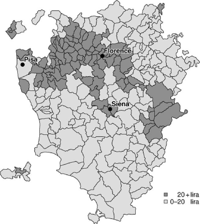
Source.
Archivio di Stato di Firenze, Catasto della Toscana, b. 934. shows the value of the taxable land rent for each community. The area with higher levels of taxable income coincides almost precisely with the mixed cultivation territories hinged on the traditional Tuscan plot (Figure 13.2). This is also the land where most of the population of the region is concentrated (Figure 13.3). The central and bearing axis of this compact territory is the path of the River Arno, which horizontally connects Pisa and Florence and, after a sharp curve slightly north of Florence, traces the outline of a wide arc reaching the plain of Arezzo. Its basin becomes particularly wide along its horizontal stretch due to the ramifications of its tributaries towards both the north and the south.Because of the central position of the Arno, this territory was called the Toscana del flume (Tuscany of the river). It opposed the ‘other Tuscany', which consists of the mountainous territory of the Apennines further north, the area south-east of Siena—la terra senza dolcez%a d'albero (‘the land without the harmony of trees')—mainly fit for seed and, on the south-west, the Maremma marshes, where the massive work of drainage undertaken during the first half of the nineteenth century had not ameliorated its desolate landscape (Table 13.1).
Figure 13.2 Percentages of mixed crop cultivation, Grand Duchy of Tuscany (1834)
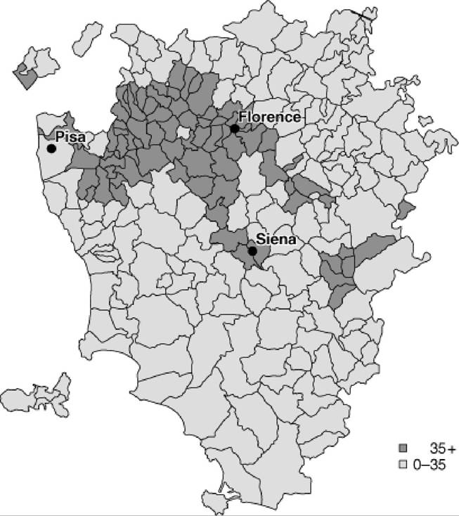
Source.
Biagioli 1975.Figure 13.3 Population density in km2, Grand Duchy of Tuscany (1823—54)
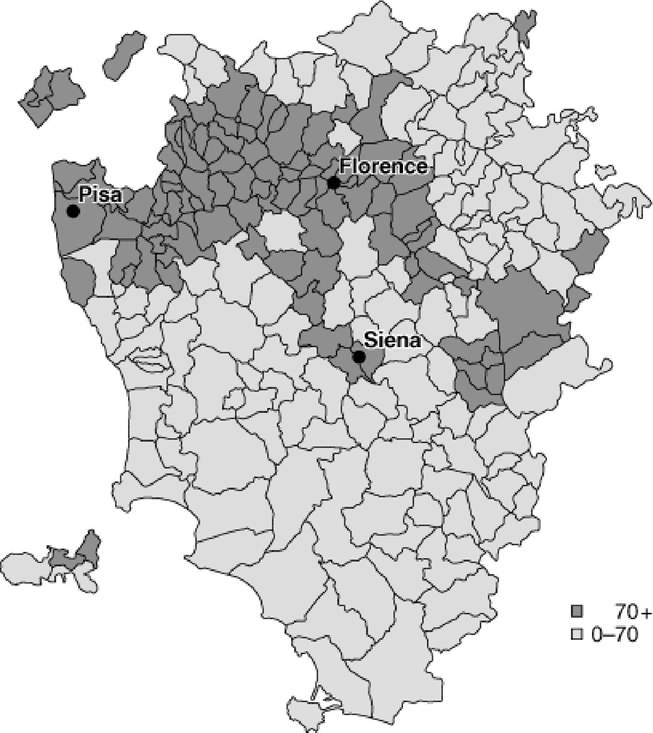
Source. Archivio di Stato di Firenze, Stato civile di Toscana. Statistica decennale bb. 12182-3.
Table 13.1 Grand Duchy of Tuscany. Principal socio-economic indicators (1832-4)
| Tuscany of the river | Tuscany of the river | Other Tuscany | Grand Duchy |
| Area (%) | 32 | 68 | 100 |
| Inhabitants (in %) | 66 | 34 | 100 |
| Inhabitants per km2 | 133 | 33 | 64 |
| Taxable land rent (in %) | 72 | 28 | 100 |
| Value (lira) per ha | 50 | 9 | 21 |
| Land for mixed cultivation (in %) | 72 | 28 | 100 |
| Real rent (in %) | 85 | 15 | 100 |
| Number of weekly markets (in %) | 66 | 34 | 100 |
| Amount of trade in weekly markets (in %) | 85 | 15 | 100 |
Note: The markets data refer to the year 1854. Source: Pazzagli 1992: 41, 46.
The ‘Tuscany of the river' region covers an area of about 7,000 km2, one third of the whole of Grand Duchy, and includes 66% of the total population (around 1.4 million) with a density of 133 inhabitants per km2, against 33 inhabitants per km2 present in the ‘other Tuscany'.
The difference is even more striking when considering the rent values. Three quarters of the whole land income, that is, the main source of wealth in an agrarian area such as the Grand Duchy, is concentrated in the river countryside. This gap is also reflected in the average value per land unit (fifty lira against nine lira per ha) and therefore in the value of the plots, which was 5—6 times higher in the ‘Tuscany of the river' region. The data reported in Table 13.1 also highlight the close relation between the number of inhabitants, the land rent, and the use of the land. The ‘Tuscany of the river' region represented in the nineteenth century a third of the Grand Duchy territory, 72% of which was characterized by mixed cultivation and it contained 66% of the entire population and produced 72% of the income.The three elements illustrated so far (inhabitants, rent, and land usage) and the close relationship that united them makes us clearly understand the great differences between the region of Tuscany hinged on the Arno river and the so- called ‘other Tuscany'. The gap becomes more evident when other indicators are explained. In fact, the data about the real rent (Table 13.1) indicate 85% of taxable rent coming only from the ‘Tuscany of the river' region, proof of the wide and dense network of towns, villages, and castles that made the region a particularly populous and active rural centre. In the central-southern part of the region, near Siena, only two towns—Volterra and Montalcino—out of the fourteen bishop-ruled towns contained more than 2,500 inhabitants. Here, as in the mountains, the populated centres were far apart and looked over an empty and large territory, characterized by scattered sharecropper settlements, as in the Senese.
The urban centres represent the nodal points of the territory not only because of their administrative and jurisdictional functions, but also thanks to their role as food-centres and as markets for the countryside produce.
Even here the data are clear in giving the same percentage; 66% of Tuscan weekly markets and 66% of Tuscan inhabitants are located in the ‘Tuscany of the river'. The amount of trade in the river area was even higher, reaching 85%, which is equivalent to the real rent level, indicating that the richest part of the region is hinged on the Arno river. If the gap between the ‘Tuscany of the river' and the ‘other Tuscany' looks rather clear at the level of macro indicators, it becomes less clear when the size and characteristics of the rural population are taken into consideration. The economy in the region was based on agriculture: according to different estimates, however close, 55% of the active population worked on the land. The figure rises to 68% when considering only the rural area land (Bandettini 1956; Pazzagli 1992). It can be assumed that in the countryside and in the smaller districts about three of every four inhabitants lived in rural families. The degree of rurality appears to have been higher in the Senese countryside, where 75% of the workers were employed on the land, while in the countryside around the Arno river the percentage falls to well below 70%. The various occupations of the people in the mountainous region, as well as the instabilityand mobility of the inhabitants of the Maremma region, make the estimates of the size of the agricultural population even more uncertain. However, even in these two areas the land, as well as the complementary and integrative activities of breeding, forestry, and vegetal coal production, remained pivotal to the local economy.
However, in an agricultural world universally hinged upon sharecropping and—excluding the mountainous areas—characterized by large landed properties,2 important differences seem evident at the territorial level.
Some of the research carried out at the micro-level allows us to outline a few differentiating features of the rural populations in the south and the north of Tuscany (Torti 1979, 1982; Pazzagli 1980, 1992; Doveri 1990).
The first one, as indicated by Table 13.1, concerns the different number of inhabitants for each cultivated hectare of land. In the ‘Tuscany of the river' region, such an indicator takes values that are around 1.5 inhabitants rising to above 2.5 inhabitants in the more intensively cultivated areas. In the Senese countryside, in spite of the predominance of rural population, the ratio takes very low values (just over 0.5 inhabitants). This relatively low value is the effect of extensive allotment, of a low degree of agricultural intensity and the widespread use of letting a third or a fourth of the arable land to lie fallow every year.In other words, the small, rich, and much exploited plots found in the ‘Tuscany of the river' region called for more workers than those necessary to manage the large, less specialized, and only partially exploited plots in the south. It is in fact with greater land availability that the Senese worker can reduce (and maybe overcome) the apparent gap separating him from the farmers of the more intensively cultivated lands in the ‘Tuscany of the river' region. Moreover, although the evidence is thin, it appears that both farm labourers and wage earners were becoming more numerous in the river area. Where it is possible to identify the different rural categories of the population, the proportions of these agricultural wage earners reach one-fifth and one-third respectively3 The proportions found in the southern area are significantly smaller.
Finally, if we consider that the wage earners and the daily workers were joined by a good part of those indicated as ‘destitutes' in the 1841 census, the ‘Tuscany of the river' region—being more wealthy than the other one—could possibly have had proportionally many more poor people. The greater presence of urban centres, where the outcasts and the destitutes were more numerous, could also explain this.
3.